


77-Voting District, Manatee County, Florida
About
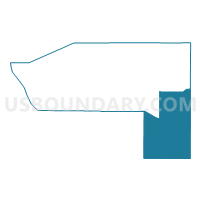
Outline

Summary
| Unique Area Identifier | 555006 |
| Name | 77-Voting District |
| County | Manatee County |
| State | Florida |
| Area (square miles) | 186.55 |
| Land Area (square miles) | 185.79 |
| Water Area (square miles) | 0.75 |
| % of Land Area | 99.60 |
| % of Water Area | 0.40 |
| Latitude of the Internal Point | 27.30328910 |
| Longtitude of the Internal Point | -82.14493660 |
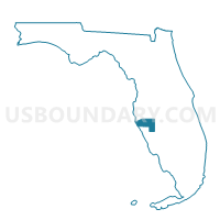
Maps

Graphs
Select a template below for downloading or customizing gragh for 77-Voting District, Manatee County, Florida


Neighbors
Neighoring Voting District (by Name) Neighboring Voting District on the Map
- 109SCM-Voting District (Saddle Creek & Myakka (109, 54, 16, 132, 112)), Sarasota County, FL
- 112LWR-Voting District (Lakewood Ranch (112 & 154)), Sarasota County, FL
- 129-Voting District, Manatee County, FL
- 134-Voting District, Manatee County, FL
- 3-Voting District, DeSoto County, FL
- 4-Voting District, Manatee County, FL
- 5-Voting District, Hardee County, FL
- 53S72-Voting District (State Road 72 (53 &145)), Sarasota County, FL
- 8-Voting District, DeSoto County, FL
Top 10 Neighboring County Subdivision (by Population) Neighboring County Subdivision on the Map
- Sarasota CCD, Sarasota County, FL (179,307)
- Myakka City CCD, Manatee County, FL (43,304)
- Interior County CCD, Sarasota County, FL (29,743)
- Parrish CCD, Manatee County, FL (22,183)
- Wauchula CCD, Hardee County, FL (14,689)
- Arcadia West CCD, DeSoto County, FL (11,611)
Top 10 Neighboring Unified School District (by Population) Neighboring Unified School District on the Map
- Sarasota County School District, FL (379,448)
- Manatee County School District, FL (322,833)
- DeSoto County School District, FL (34,862)
- Hardee County School District, FL (27,731)
Top 10 Neighboring State Legislative District Lower Chamber (by Population) Neighboring State Legislative District Lower Chamber on the Map
- State House District 67, FL (241,034)
- State House District 71, FL (183,147)
- State House District 72, FL (167,184)
- State House District 66, FL (162,026)
Top 10 Neighboring State Legislative District Upper Chamber (by Population) Neighboring State Legislative District Upper Chamber on the Map
- State Senate District 21, FL (529,870)
- State Senate District 23, FL (458,330)
- State Senate District 17, FL (456,960)
Top 10 Neighboring 111th Congressional District (by Population) Neighboring 111th Congressional District on the Map
Top 10 Neighboring Census Tract (by Population) Neighboring Census Tract on the Map
- Census Tract 9703, Hardee County, FL (8,169)
- Census Tract 27.13, Sarasota County, FL (8,152)
- Census Tract 9704, Hardee County, FL (6,520)
- Census Tract 20.15, Manatee County, FL (5,449)
- Census Tract 20.10, Manatee County, FL (4,019)
- Census Tract 104.04, DeSoto County, FL (3,270)
- Census Tract 19.14, Manatee County, FL (2,899)